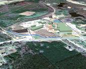
 Oblique view of site layout for Coastal Lumber in Havana, FL
When we think about the application of a geographic information system we tend to think in
terms of characterizing and modeling areas such as a county, region, a state, or collection of
smaller sites. Likewise, when we think of a site plan, like a factory, shopping mall, or military
base we used to associate these facilities as best characterized using CAD-based systems.
GIS technology has had major breakthroughs in applications relating to asset databases, providing a highly
useful option for facility management. CAD data is easily accessed and incorportated into a GIS. The benefits of using GIS in facility characterization and modeling are many and
produce an end product which is far superior to a CAD-only model. These include; efficient dissemination of information providing comprehensive views, Streamlining asset information and collection, and the provision of better planning and analysis.
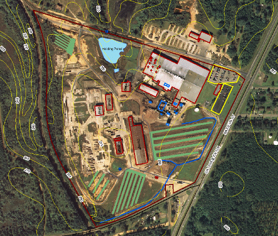
For example, facility data can be analyzed on a room-level basis, and as a result, space and asset management are greatly enhanced. This can used to better assess space and assets and work toward putting them to their best and highest use. GIS can also be used in facility management to develop or augment master planning and expansion of facilities.
Existing databases recording site maintenance history, utilities, space location, and storage, parking and computing systems can all be incorporated into a GIS facility management system to ensure continuity of operations and increase data integrity. Valuable spatial analyses can be completed for a facility such as calculating a cost per area or weighing the cost of building maintenance against replacement costs. One can evaluate energy use per area and target areas needing focus for conservation. Examples include; manufacturing plants, golf courses, waste management and pick up, large land holders, large land management companies, and even buildings.