Introduction
 The primary purpose of the Leon County Aquifer Vulnerability Assessment (LAVA) project is to provide a science-based, water-resource management tool to help minimize adverse impacts on ground-water quality, including focused protection of sensitive areas like springsheds and ground-water recharge zones.
 Located mainly on the Woodville Karst Region, Leon County is underlain by thick and very permeable limestone layers and other carbonate rocks which make up the Floridan Aquifer System (Pratt et al., 1996). Sinkholes, swallets, river rises, springs and their springsheds and other karst features are common throughout the area. These karst features can enhance the hydrologic interactions between land surface and the underlying Floridan Aquifer System.
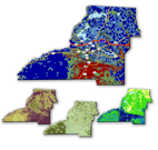
The finished output for the LAVA project consists of a probability map displaying zones of relative aquifer vulnerability across the Leon County study area. The LAVA project takes advantage of the most recent and resolute data available and provides a highly usable end product for planners, developers, and regulators working on the local level to develop solutions to water resource issues.
UPDATE: The LAVA project results were generalized to establish a primary springs protection zone map. You may access some of the information and data associated with the projects below. Click the link here to view the protection zone presentation by the leon county planning department. LCSPZA
Presentation to Leon County BCC, October 9 Workshop Meeting
Draft versions of Project Report, Poster, and Data (draft version 1.1, submitted 7-19-07)
*Note:
The LAVA data file is very large and may require a long time to download.
You will need WinRAR, a free program, to extract the data files (click to visit website).
ESRI software is required to view the GIS projects. ArcReader is free of charge (click to visit website).