Advanced GeoSpatial is a full service GIS company. We are intent on promoting stewardship of natural resources and streamlining business processes through the development and application of geographic information systems. Please select the links below to see more about how we use GIS to add value to our clients’ projects.
Predictive Spatial Analysis
 AGI generates aquifer vulnerability assessments to assist community planners, environmental
regulators and resource managers, local governments, developers, and other environmental
professionals in meeting their objectives to protect ground-water resources. [more]
AGI generates aquifer vulnerability assessments to assist community planners, environmental
regulators and resource managers, local governments, developers, and other environmental
professionals in meeting their objectives to protect ground-water resources. [more]
Site Suitability Analysis
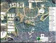
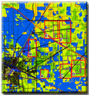 Selecting the ideal site for an application can require exhaustive records and parcel searches.
AGI designs analyses of study areas which can eliminate or reduce searches by pointing out best
suited areas. [more]
Selecting the ideal site for an application can require exhaustive records and parcel searches.
AGI designs analyses of study areas which can eliminate or reduce searches by pointing out best
suited areas. [more]
Infrastructure Mapping and Modeling
 GIS provides a powerful and useful tool for the mapping and modeling of infrastructure features. [more]
GIS Needs Assessment
 Thinking about a GIS Program for your organization? Then you may be thinking about cost justification for a good program and trying to answer questions about software, costs, adding staff, and expanding computing abilities. [more]
Real Property Mapping and Analysis
 GIS provides a highly functional tool which allows you to view and analyze properties in your
area with a few clicks of a mouse button. [more]
GIS provides a highly functional tool which allows you to view and analyze properties in your
area with a few clicks of a mouse button. [more]
Facility Layout and Management
 Existing databases recording site maintenance history, utilities, space location, and storage,
parking and computing systems can all be incorporated into a GIS facility management system to
ensure continuity of operations and increase data integrity. [more]
Existing databases recording site maintenance history, utilities, space location, and storage,
parking and computing systems can all be incorporated into a GIS facility management system to
ensure continuity of operations and increase data integrity. [more]