Please browse our map gallery below to view some of the maps and data we have produced in meeting our clients’ needs.
Property Analysis & Mapping

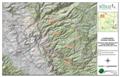
Plantations in the Red Hills Area Superior Map Design
Wakulla Spring Basin, North Florida Wetlands Analysis
Wetland Extent and Type Estimate Aquifer Vulnerability
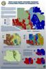
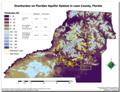
Marion County Aquifer Vulnerability Assessment

Plantations in the Red Hills Area Superior Map Design

Wakulla Spring Basin, North Florida Wetlands Analysis

Wetland Extent and Type Estimate Aquifer Vulnerability

Marion County Aquifer Vulnerability Assessment
Geologic Mapping
Characterization of geologic units Integrated GPS/GIS

Location of field samples and thickness characterization Interactive Map Design
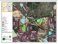
Eastern Leon County, Florida Preferred Site Modeling
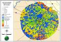
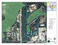
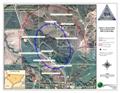
Well Field Siting Project, Live Oak, Florida

Characterization of geologic units Integrated GPS/GIS

Location of field samples and thickness characterization Interactive Map Design

Eastern Leon County, Florida Preferred Site Modeling

Well Field Siting Project, Live Oak, Florida
Custom Mapping Design
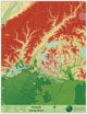
Select Plantations of Lamont and outlying areas Digital Elevation Display
Wyoming Ranch Topography Water Well Survey
FDEP required nearby well survey Custom Mapping Design

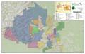
Biological Resources, Jefferson County, Florida

Select Plantations of Lamont and outlying areas Digital Elevation Display

Wyoming Ranch Topography Water Well Survey

FDEP required nearby well survey Custom Mapping Design

Biological Resources, Jefferson County, Florida